
Amsterdam, the Netherlands: Exploring the City Without the Crowds

Have you ever walked through a famous city and felt as if you had it almost to yourself? Well, that was our experience in Amsterdam.
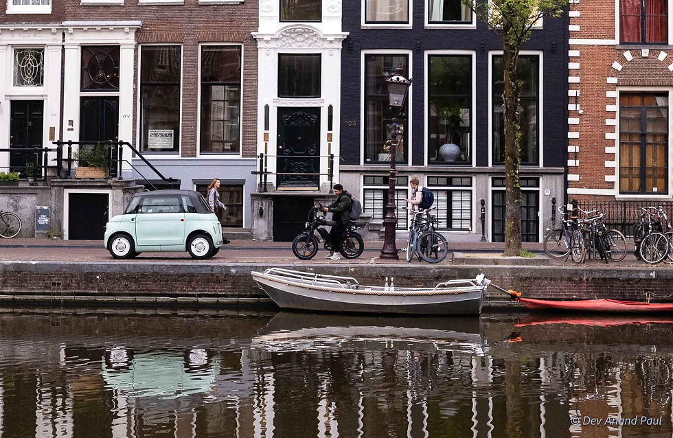
At 6:00 in the morning, we stepped out of Amsterdam Centraal (Amsterdam Central Station) and into a city that was waking up. Restaurants and cafés were closed, tour boats moored along the canal walls, and bike lanes empty. Ahead lay the old centre—canals, bridges, and narrow high-rise brick houses.

We started early because we wanted to experience Amsterdam’s historical centre at our own pace before the daytime crowds arrived. We had mapped a simple on-foot exploration loop: from the station, to Damrak, through historical canals and past Oude Kerk and De Wallen, then towards the Amstel River and De Waag and back to the station


Amsterdam grew from a settlement along the Amstel River, in a landscape of peat and waterlogged marshland difficult to farm and build on. By the 13th century, people had begun building dikes and digging drainage ditches to control the water, and a dam was constructed across the Amstel, linking the communities on either side.
The earliest written record on the place dates to 1275, when Count Floris V granted the inhabitants a toll privilege. This document referred to the place as Amestelledamme, meaning ‘a dam in the Amstel’, the local river; it later morphed into Amsterdam. The waterways that had shaped Amsterdam’s early development are still an important part of the city.

We started our walk from the Central Station towards Damrak, a main avenue in the historical centre of Amsterdam, leading from the station to Dam Square. Damrak was also once an important commercial waterway linking the Amstel with the IJ, another waterway running through Amsterdam.
As the city was still waking up, the water was almost completely still, with beautiful reflections of the morning sky and the buildings along the canal.
Shortly, we arrived at a row of houses in Damrak that Amsterdam is probably most famous for—the ‘dancing houses’. Built during Amsterdam’s 17th-century expansion, when the city was transforming into a major trade centre, these narrow houses are called so because they do not stand at identical angles. Some tilt towards the street, while others appear to have settled at different angles.

You might wonder why the buildings are leaning. The answer lies in their foundations. Because the ground was marshy with soft clay soil and peat, wooden piles were driven deep to reach a more stable layer of sand and support the heavy brick buildings. Over centuries, the rotting or shifting of the piles caused these houses to sink and lean to either side.

The shape of the houses depended on land use. Canal-side land having been valuable, plots were kept narrow and extended deep behind the street frontage. City building rules also set limits on the size and layout of plots and buildings, resulting in the familiar Amsterdam houses: narrow at the front, deep behind, and often multi-storied.
Farther along Damrak, we passed the red-brick Beurs van Berlage (Berlage’s old stockmarket building). Designed by architect Hendrik Petrus Berlage, and completed in 1903, the building was constructed as a commodity exchange. Its architecture is much more restrained than the gabled canal houses, and its clock tower rises about 40 metres.

From here, we turned onto Warmoesstraat (‘chard street’), one of the ancient streets in the city. Warmoes was an old Dutch word for chard or greens, and the street name reflects the road’s association in the past with a vegetable market. Today, however, it is busy with shops, restaurants, budget hotels, cafés, bars, and sex boutiques. In the early morning, though, it was quiet.

As we continued our walk along the canals, we noticed that several canal houses had a slight forward tilt; also, large wooden beams with massive iron hooks were jutting out from the gables of these houses. Merchants and residents used these beams, pulleys, and ropes to lift heavy furniture and cargo directly from the boats to the upper-floor windows, because the staircases inside these extremely narrow houses were too steep and narrow to carry large goods. And the forward tilt, often intentional unlike the side tilts caused by the unstable soil conditions, protected the building façade and windows from getting damaged during such lifts.
These houses were designed so the upper floors could store goods or serve as residences, while the ground floors served as shops or workplaces.

We left the harbour area and turned south along the Oudezijds Voorburgwal, one of the oldest canals in Amsterdam. The long glass-topped tour boats were stationary along the quiet canal. As the day unfolded, these waterways would become busy with sightseeing boats and pedestrians.
A few minutes later, we reached Oude Kerk (‘old church’).

The Oude Kerk is the oldest surviving building in Amsterdam. It began as a wooden chapel in 13th century, which was later converted into a stone church and consecrated in 1306. Over the following centuries, the building was enlarged several times until it became the large Gothic hall church we see today.
What caught our attention was the way the small brick cottages were built closely around the church. Rather than having their own foundation, these tiny homes were built against the church walls, right beneath the Gothic windows. We realized just how cramped the old part of town became as it grew.

The next landmark in our foot safari was Oost-Indisch Huis (East India House), on Kloveniersburgwal, another historical canal in the city centre. Completed in 1606, it became the headquarters of the Amsterdam chamber of the Dutch East India Company, the VOC (the world’s first multinational company). From here, the company managed trade and administration across a network that extended far beyond the Netherlands. Its expeditions to the Orient, especially, brought back silks, spices, and other riches, propelling Amsterdam into one of the wealthiest cities in the world in the 17th century—the golden age of Amsterdam. The Oude Kerk reflected Amsterdam’s medieval past, while the Oost-Indisch Huis represented the city’s growing involvement in overseas trade.
The edifice is now part of the University of Amsterdam.


From Kloveniersburgwal canal, we crossed to a parallel canal, the Oudezijds Achterburgwal, and entered De Wallen, Amsterdam’s Red Light District.
Owing to its proximity to the harbour, this part of Amsterdam has been associated with sailors and prostitution since the Middle Ages. The name Red Light District came much later. A commonly told story is that, in the late 19th century, prostitutes used to place red gas lanterns outside their rooms to show that they were available. Another story, more a folklore from the United States rather than established history, says that railway workers left their red signal lanterns outside brothels so their crew members could find them.
We then continued towards the Amstel, crossing several old bridges along the way.
The first one, Sleutelbrug, spans across Grimburgwal, another small historical canal in the city centre, built in 1450. Right next to this bridge lies Huis aan de Drie Grachten, or the ‘House on Three Canals’, a 17th-century brick mansion dating from 1610. Its three façades each face three different canals, unique in Amsterdam, hence the name.


Next was Aluminiumbrug (Aluminium Bridge) farther along the Kloveniersburgwal canal. Dating from 1896, it is a dark iron drawbridge that connects two streets, Staalstraat on the east bank and Nieuwe Doelenstraat on the west bank. Its present name came later, after an aluminium deck was installed during the 1955 renovation.


Crossing another bridge brought us right in front of the Tivoli Doelen Amsterdam Hotel. Its history goes back to the 15th century, when it started as a defence tower known as Swych Utrecht (‘Be quiet, Utrecht’). Later, during the Dutch Golden Age, the site became associated with the city’s civic guard, the Kloveniersdoelen. And in 1882, the tower was demolished and the Doelen Hotel was erected in Neo-Renaissance style.
It welcomed Empress Elisabeth of Austria, aka Sisi, in 1884 and 1886 and The Beatles during their 1964 visit.

The narrow canals eventually opened onto the wide waters of the Amstel River. Here, the wedge-shaped Hôtel De L’Europe stood on the riverbank, its ornate 19th-century brick façade looked like a grand ship anchored at the water’s edge.

We headed north along the Kloveniersburgwal towards Nieuwmarkt (‘New Market’), a lively square. At its centre stood De Waag, Amsterdam’s oldest secular building. With its thick masonry walls, round turrets, and pointed towers, it looks like a medieval fortress, and rightly so.
De Waag was originally built in 1488 as one of the city’s fortified gates. As Amsterdam expanded, these old defensive structures lost their importance. The moat was eventually filled in and converted into a marketplace, and the former gate was altered to a municipal weigh house.

As we started to walk back towards Amsterdam Centraal, we saw a few locals cycling. Trams were beginning to rumble through the streets, and garbage trucks were moving. Amsterdam was starting its day.
By 9:00 a.m., we finished our self-mapped loop. Although we had covered only a small part of the historical centre, we had walked through several periods of Amsterdam’s history, seeing how the city burgeoned around the Amstel, how it dealt with its wet ground, how trade shaped its buildings and streets, and how its commerce eventually connected Amsterdam with a much larger world.
Related posts
Giethoorn, the Netherlands: Beyond the Picture-Perfect Village
The Silk Road Explained: History, Trade Routes, and Cities of Uzbekistan
Registan Square, Samarkand: Understanding the Evolution of Islamic Architecture in Central Asia
Rishton Pottery: Uzbekistan's Ancient Blue Ceramics Along the Silk Road
Inside a Margilan Silk Workshop: How Traditional Ikat Silk Textile Is Made in Uzbekistan
Khiva, Uzbekistan: Itchan Kala, Silk Road Trade, and the City’s Hidden History
Bibi-Khanym Mosque, Samarkand: One of Islamic World’s Largest Mosques
Chilpik Dakhma, in Uzbekistan: Zoroastrian Towers of Silence and Parsi Migration to India
Tashkent Metro Stations: A Glimpse into Their Unique Underground Architecture
Aydarkul Lake, Uzbekistan: A Desert Lake Born from Soviet Irrigation
Samarkand Paper: A Visit to Konigil Meros Paper Mill in Uzbekistan
The Story of Indian Coins: 2600 Years of Wealth, Power, Trade, and Culture
Bhutan Postage Stamps: How a Small Kingdom Revolutionized Global Philately
The Battle of Colachel: How a South Indian Kingdom Defeated the Dutch
My Son Sanctuary: The Cham Temples of Vietnam and Their Indian Connection


Comments