
Aral Sea Disaster and Its Environmental Impacts: The Moynaq Ship Graveyard and Aralkum Desert
- devanandpaul
- May 9
- 7 min read
The Aral Sea disaster turned one of the world’s largest inland seas into a salty desert within a few decades. In Uzbekistan, former port towns like Moynaq now lie far from the Aral Sea waters, surrounded by a massive dried seabed—the Aralkum Desert—and rusting ships. This catastrophe was caused by the diversion of the Amu Darya and Syr Darya river waters for irrigation during the Soviet era, which resulted in huge ecological and economic adversities across the region.

A few years back, I came across the story of the Aral Sea on social media, accompanied with stark images—corroded ships stranded in sand and a sea reduced to a fraction of its former size. I found it hard to comprehend the magnitude of the disaster, and since then have wished to see what was left of the towns that once depended on the Aral Sea. So when I was planning a trip to Uzbekistan, I included the Aral Sea in my itinerary. And in this blog post, I explore the Aral Sea disaster and recount my trip across the former seabed.
The Aral Sea History: From the World’s Fourth-Largest Lake to an Environmental Disaster
The Aral Sea is located in Central Asia, between northern Uzbekistan and southern Kazakhstan. It supported fishing communities for centuries. The sea was fed by two major rivers, the Amu Darya and the Syr Darya, which replenished the water lost by evaporation. As long as the inflow equalled the loss on evaporation on average, a sustainable ecosystem was maintained naturally. That changed in the 1960s, when Soviet planners initiated a massive irrigation project, which diverted the rivers for cotton production.


The water level started falling because of evaporation and reduced replenishment from the rivers, and within decades its shorelines retreated significantly. Now, in the mid-2020s, more than 90 per cent of the sea has disappeared. What began slowly soon became irreversible, leaving behind a vast salty desert (more than 3 million hectares of seabed), now known as the Aralkum Desert.

As salinity rose to triple that of the oceans, all the sea’s native fish species perished; consequently, the fisheries collapsed. Winds blowing over the dried seabed carry salt and toxic dust across nearby towns and farms, damaging crops and degrading soil. And people inhabiting the region suffer chronic health problems and face unusually high rates of respiratory illness, throat cancers, anaemia, and kidney and heart diseases, not to mention infant mortality—among the highest in the world.

This transformation—from sea to desert within decades—stands as one of the worst human-made environmental disasters.
Nukus to Moynaq: The Route to the Aral Sea
I had planned a 1-day trip to the Aral Sea, starting from Nukus to Moynaq (200 km), then across the vast stretch of the exposed seabed to the remaining Aral Sea waters, and back to Nukus via the Ustyurt Plateau.
At six in the morning, we left Nukus, the main town near the former shoreline of the Aral Sea. After a 2-hour drive, we reached the town of Moynaq, a once-thriving fishing port on the Aral Sea, now about 150 km away from the Aral Sea’s waters, stranded in the Aralkum Desert and known today for dark tourism.

The town felt abandoned—scattered houses, quiet streets. Even food was scarce; after some effort, we managed to find samsas for breakfast. Satiated, we drove towards the Aral Sea Museum.
The Aral Sea Museum
The Regional History and Aral Sea Museum is located in the town of Moynaq, in Karakalpakstan, the autonomous region in northern Uzbekistan. The museum features photographs and paintings that depict how life in this port town depended on the Aral Sea before it started disappearing—trawlers along the shore, workers unloading their catch, a port in full operation. It also houses taxidermy birds and animals, and everyday objects—canned goods (from the local cannery, long since abandoned), household items, and small art and craft pieces of the people who lived along the Aral Sea shores. You can as well see pictures and paintings of the shrinking Aral Sea between 1960s and 1980s and its impacts on the environment.
The Aral Sea Memorial stands outside the museum, with the old lighthouse behind it.


The Moynaq Ship Graveyard: Rusted Fishing Boats in the Aralkum Desert
The Moynaq Ship Graveyard is very close to the museum. After visiting the museum, we walked up to a ridge—once the shoreline—from where we could see the ‘ship graveyard’ below: Abandoned fishing vessels lie scattered across the former seabed in a line, dragged from where they had last been functioning. We made our way down the ridge and walked towards them. The sandy ground was rippled by wind and dotted with low shrubs as far as the eyes could see.

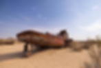
The boats are rusted and their hulls are covered with graffiti. The window and door frames are empty—no glass, no doors—only dark openings cut into the hulls.


I climbed inside a boat. The floor was uneven, with sections missing. Sunlight fell through gaps, warming the interior and casting sharp shadows. The metal was rough and flaking, and left rust on my fingers. Outside, the parched seabed stretched to the horizon—no water, no movement.
The Drive Across the Aralkum Desert: Crossing the Dried Aral Seabed
Our next stop for the day was the remaining body of water (the shrunken Aral Sea). From Moynaq the route runs into the Aralkum Desert—the exposed seabed. There is no road. Our driver Rasul (+998 937728989) followed small colour-coded flags marking the path.

For hours we drove over what was once covered with water. The terrain alternated between soft sand, cracked clay, and stretches of saline mudflat, with scattered shrubs. The entire place was desolate except for occasional tourist cars. Crested larks and Isabelline wheatears moved across the ground, and eagles and buzzards circled above.

As we pressed on, the idea of a sea began to feel unreal. It was easier to think of it as a desert. After nearly 5 hours, a thin blue line appeared on the horizon—the Aral Sea.

The Aral Sea: What Remains of a Lost Inland Lake
My first impression on reaching the Aral Sea was its scale—even in decline, it still looks expansive. The edge was subdued: no breaking waves, only bands of foam along the shore.

The exposed dry seabed spans in every direction—flat, pale, streaked with salt. The horizon stretches far, as if the sea has pulled back but not completely disappeared.
Standing there, I found the loss difficult to grasp.
The Ustyurt Plateau, Uzbekistan: Cliffs Along the Aral Sea
After spending an hour at the Aral Sea, we drove towards the Ustyurt Plateau. It rises abruptly from the dried seabed—a steep cliff running adjacent to the Aral Sea’s western edge. Sparse patches of muted green cling to the slopes.

Once the vehicle climbed up, we stopped at the edge of the cliff to get a last glimpse of the Aral Sea. A cold wind was blowing, which literally pushed us from our spot. The view of the sea was beautiful.

The Ustyurt Plateau is a 200,000-square-kilometre-vast semi-desert stretching across Uzbekistan and Kazakhstan, between the Aral Sea in the east and the Caspian Sea in the west. It was formed over millions of years from an ancient seabed. At its edges, the plateau drops steeply to the Aral Sea.
We continued our drive back, passing through canyons and limestone-and-chalk cliffs, and then, again, across vast stretches of the dried seabed, and reached Moynaq, where we finally fell back on the asphalt road. From there, a 2-hour drive deposited us at Nukus around 11:30 p.m. We had been on the road 18 hours that day. To say the drive through the salty desert was exhausting is an understatement!

The Aral Sea did not disappear on its own. It was reduced by design. The irrigation system that shrunk it still operates. The cost is visible in the massive expanse of the desolate exposed seabed and in the towns that depended on its waters. The trade-offs were known: more water for irrigation, higher production, economic gain. The benefits came first. The damage came later.

This is not an isolated case. Similar decisions are taken across countries—forests cleared, rivers redirected, coastlines altered, natural resources extracted faster than they can recover. The details differ, but the trajectory remains the same. By the time the cost becomes visible, the lands are beyond restoration.

Related posts:
The Silk Road Explained: History, Trade Routes, and Cities of Uzbekistan
The Story of Indian Coins: 2600 Years of Wealth, Power, Trade, and Culture
Bhutan Postage Stamps: How a Small Kingdom Revolutionized Global Philately
The Battle of Colachel: How a South Indian Kingdom Defeated the Dutch
My Son Sanctuary: The Cham Temples of Vietnam and Their Indian Connection
Armenian Church in Old Dhaka: History, Trade Networks, and the Legacy of Armanitola